Candlestick Point State Recreation Area is the southeastern most point of the trail, and also the most remote trail head to reach, at least by urban standards. The closure of Hunters Point Expressway to cars in 2023 makes it more confusing, but the park is open and accessible by car, bicycle, and on foot.
Here are some hints on public transit, walking, bicycling, and by car.
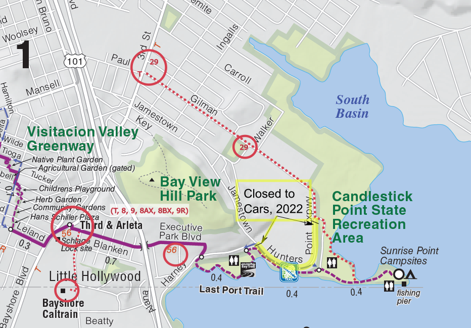
Driving and Parking
You can park in the main Candlestick Park parking lot, but the gates get closed and locked early. You may wish to park at another section and take transit/rideshare to the park. As of September 2023, the main lot (500 Hunters Pt Expwy) is open 7 a.m. to 7 p.m. and the Lost Port lot (160 Harney Way) is open from 8 a.m. to 5 p.m. There is also some parking on the streets surrounding the business park next to US-101 which is walking distance to the park.
As of early 2023, Hunters Point Expressway is blocked to cars. Enter the park by driving to the end of Gilman Ave and bearing left then right. A good waypoint is to enter ‘Candlestick RV Park’ into a GPS then continue southeast to the parking lot. The “Pelican Group Picnic Area” is a good point in many map systems for the closest parking lot.

Google Maps and other mapping services should know about the detour and show you a route like the above, but occasionally will show an incorrect route.
Our recommendation is that you take public transit, but we recognize that can be a challenge.
Public Transit
As of December 2024, you can also take the Bayview Shuttle directly to Candlestick! See our article on the Bayview Shuttle.
Most sections of the 17-mile Crosstown Trail are easily accessible from public transit. The east end of Section 1 in Candlestick Point State Recreation Area is an exception. Sunrise Point is an 0.6-mile walk or ride from the park entrance, and the closest public transit stops are 1.0 to 1.7 miles away. Here are two routes of roughly equal length:
Google Maps marks the start of the Crosstown Trail by “Sunrise Point Fishing Pier.”
Via Bayshore and Arleta (Muni)
Take the T-Third, 8, 8AX, 8BX, 9 or 9R to the Arleta stop on Bayshore Blvd. Walk east on Blanken Ave. and follow the instructions on the Cue Sheet for “Section 1 Hike South: Glen Park BART Station to Sunrise Point.” The total distance is about 1.7 miles.
You can shave 0.5 mile off this walk by taking the 56-Rutland bus east from Blanken Ave. and Bayshore Blvd. to the terminus on Thomas Mellon Drive in SF Executive Park. This bus runs approximately every half hour. Go downhill to Harney but don’t cross here! Turn left (east) 1 block on the north side of Harney to the 3-way stop sign and crosswalk. Cross Harney then follow the trail left 0.5 mile to the park entrance and another 0.5 mile to Sunrise Point.
Via Bayshore Caltrain
The Caltrain Bayshore stop is on Tunnel Ave. Turn left on Tunnel Ave and walk 2 blocks north to Blanken. Here turn right and follow the Section 1 Southbound Cue sheet, or if you’re lucky you can hop the 56 bus for a few stops to the east end of the line and walk from there.
Via Third and Gilman (Muni 29)
This access point is most useful to connect between trail sections by the 29-Sunset bus .
The T-Third’s Gilman/Paul stop is also the 29 Sunset bus terminus. The walk to Sunrise Point from here is 1.6 miles. Head southeast 1.0 mile on the left side of Gilman Ave. The road turns south as Hunters Point Expressway. In about 1 block turn left at the main entrance to Candlestick SRA. Angle right on the park road, then left on a paved trail heading south. Bear left to reach the shore of South Basin, then turn right to follow the paved path 0.6 mile to Sunrise Point (keeping South Basin on your left).
To shorten the walk by 0.6 mile, wait at the 29’s Third and Fitzgerald stop (1 block north of Gilman) and catch a 29 departing “Inbound towards Baker Beach.” The bus loops east before returning west. Ride 8 blocks to the east side of Gilman Playground and disembark as the bus turns left on Gilman Ave.. Continue right (southeast) on Gilman 0.4 mile to the park entrance and follow the instructions above.
The 29 Sunset runs every 10-20 minutes from 6AM to midnight.
Returning from Candlestick Park via transit
The best route is to retrace the Crosstown Trail back toward Bayshore/Arleta via the shoreline path. Cross at the 3-way stop to Executive Park Blvd. Continue along then left to join Blanken St. under 101. The 56 bus starts west from Thomas Mellon Way and Executive Park Blvd. at 1.2 miles, which may shorten your walk. To reach Bayshore Caltrain from Blanken St. turn left and go 2 blocks on Tunnel Road.
Alternately, exit Candlestick Park at the main entrance and turn right on Hunters Point Expressway and continue on Gilman Ave.. You can catch the outbound 29 Sunset at Gilman Park (1.1 miles) , or walk all the way to Third to catch the T-Third (1.6 miles).
Bicycle
As of 2023, the roads are a bit confusing but the address of 500 Hunters Point Expressway is correct.
From the north, take Gilman to the end then bear left then right into the park at Gilman, Follow the park road 0.2 mile to the last parking lot. Turn left at the restroom to follow the southern paved path 0.5 miles to Sunrise Point.
From the south, take Harney to Hunters Point Expressway, go through the barrier, continue past where the shoreline is right along the road, then enter the park at the next gap in the barriers into a parking lot and restroom. Go behind the restroom and follow the paved shoreline path 0.5 miles to Sunrise Point.
Ask for a ride to the “Pelican Point Picnic Area” or, if that doesn’t work, the main Park parking lot (500 Hunters Point Expressway), and ask them to continue to the very end of the parking lot. Find a paved pathway/service road to the left of the restroom follow the path 0.5 miles to Sunrise Point.
As of early 2023, Hunters Point Expressway is blocked to cars. Enter the park by driving to the end of Gilman Ave and bearing left then right. A good waypoint is to enter ‘Candlestick RV Park’ into a GPS then continue southeast to the parking lot.